PreviSat is a satellite tracking software for observing purposes. Very easy to use, it shows positions of artificial satellites in real-time or manual mode. PreviSat is able to make predictions of their passes and also predictions of Iridium flares.
PreviSat implements the SGP4 model (revised in 2006) which uses the TLE orbital elements in order to calculate the geocentric position of artificial satellites. PreviSat shows satellites in a world map view or in a sky map view and is able to calculate all passes of satellites for any location in the world. It also calculates flares produced by satellites of the Iridium constellation.
Overview
PreviSat is a simple, fast and intuitive software that displays the position of artificial satellites. Its graphical interface is designed to meet the needs of the neophyte or experienced observer. Developed in C++/Qt, it can work on all platforms (Windows, Linux, Mac OS X) and makes fast and precise calculations.
PreviSat can calculate all passes of artificial satellites for any location in the world. So you can observe passes of the ISS (International Space Station), even if you live in a city.
Below you can find a description of the most significant features of PreviSat.
Main features:
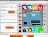
PreviSat has a real-time, a manual and a simulation mode. So you can observe the displacements of the satellites in real time, or you can display positions for any times. In the "Main" tab, the numerical position is given in different frames (terrestrial, horizontal, equatorial) and some characteristics are given depending on the satellite position (velocity, magnitude). We also give positions of the Sun and of the Moon.
The second tab gives cartesian position of the selected satellite and its osculating elements (or keplerian elements). It also calculates some parameters deriving from osculating elements, for example orbital period, apogee or perigee.
The third tab describes the TLE of the selected satellite and gives informations about brightness and dimensions of the satellite itself.
Predictions of passes
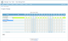
PreviSat calculates passes of artificial satellites for any location on Earth and it is possible to set many parameters (Sun maximum elevation, satellite minimum elevation...).
Flares of some specific satellites can be determinated very quickly for the given location, and we also give terrestrial coordinates of the location next to your place of observation where the flare is maximum.
Two other predictions are provided by PreviSat : the determination of ISS transits with the Sun and/or the Moon, and the calculation of orbital events.
All prediction algorithms are refined to provide precise results in a minimum of time. Compared to other similar softwares, PreviSat is widely more efficient and more accurate.
TLE tools
Two tools are developed to manage TLE orbital elements. The first one allows to update categories of orbital elements from the Internet. The second tool is able to create a TLE file from another by specifying limiting values for orbital elements.
Management of location and options for display
PreviSat provides several categories of locations. You can easily add or delete a location or a category. A category is specially created in order to manage personal locations frequently used.
In the options tab, you can choose to display or to hide the most of elements drawn on the maps at your convenience.
Supported Files
The common text file extension for a TLE is "txt", but one can find a "tle" extension. PreviSat is able to read files with a "txt" or "tle" extension. The web site Space-Track.org used to provide TLEs compressed with the "gz" format. PreviSat is also able to read this format.