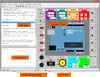
VSceneGIS Desktop
")
Free
Offline
http://www.vscenegis.com/
VSceneGIS enables the development of projects on Geographic Information Systems (GIS) for analysis, calculation and editing geographic data and creating topological models of geographic information and topological validation of objects based on defined rules.
VSceneGIS is a project (GNU / GPL) under development to facilitate the realization of Geographical Information Systems Projects. The project encompasses a set of development libraries, applications and tools, giving relevant importance to the Topology of the data, Control, Validation and Behavior of the data in the defined model, for its subsequent analysis, computation and editing.
VSceneGIS modalities:
- VSceneGIS Desktop. Client for the development of Projects, Analysis, Computation and GIS Edition. The VSceneGIS platform applies the concept of Tree and Topological Graph to implement the data model in a GIS.
- Development API for GIS applications: VSceneGIS aims to be a development under GNU / GPL license implemented in Java, currently functional in JRE 1.6_23, and in the current phase of the project the libraries are used to access WMS, WFS services from Geootols, and JideSoft's Open Common Layers for creating CheckBoxTree implemented in VSceneGIS Desktop.