GeoCalculator is based on the familiar Windows Calculator but takes geological structural data for input and output. Calculations include most common structural geometrical calculations as well as drillhole calculations for oriented, partially oriented, and unoriented core.
What GeoCalculator does?
GeoCalculator accepts and outputs structural data using a wide variety of formatting conventions for referencing lines, planes, and directions in geological space. Because input and output conventions can be set separately, GeoCalculator can be used to convert file data from one geological orientation convention and format to another.
- Calculation results are displayed instantly in the Results window, and results can be displayed in a simple stereographic projection.
- As well as instantaneous manual entry, batch data can be either pasted or read from Input files with no special requirements as to file formatting or data arrangement.
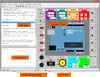
- Oriented drillhole calculations [screen shot] include not only the commonly used oriented core calculations, but also calculations for partially oriented core where a known local structural feature in unoriented core is used as a proxy for the orientation mark in oriented core. Thus oriented core marks can be extrapolated to unoriented sections of the same core, or old unoriented core can be processed as if it were oriented. (When ambiguities in this calculation occur the choices are output for manual selection). [Download manual for oriented drillcore procedures].
- Drillhole calculations also allow the output of apparent dips in nominated section planes.
- Spatial calculations include variations on 3-point problems using X,Y, Z geographic coordinates; calculations using map and unit thicknesses and orientations; lengths and areas; and downhole drillcore extrapolation.
- Conventions settings also include pre-setting terms used to describe structural features with variable international terminology. Most importantly this includes the terms used for describing oriented core angles, which vary widely from company to company. These can be preset to the local usage.
- GeoCalculator (from v4.9) is both locale aware and flexible with respect to decimal (floating point) numbers. Decimal numbers can be entered using either period or comma decimal delimiters (even mixed) and will output to either format on demand.
- Important Notice: There is a restriction on the number of data that can be input from file by unregistered users. (Paid registration removes these restrictions).
- Download the compiled Help file for specific details. As part of Microsoft's security measures you now have to Unblock the .chm file in order view it. See here for details regarding use of Help in these packages.